Note: this dataset description is metadata (data about data) which describes the actual dataset in accordance with the ANZLIC (Australia New Zealand Land Information Council) Core Metadata Guidelines Version 2 (February 2001)
ANZLIC unique identifier: ANZCW1003100028
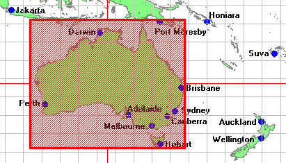
Title: IndexGeo Point Location MapServer
Custodian: IndexGeo Pty Ltd
Jurisdiction: Australia
A simple web mapping service delivering various point location datasets. Current layers include:
- Capital cities of Australia - capital_aus
- Cities of Australasia - city_austral
- Waste water artificial wetlands - wastewet
Note: This service is under development.
- Only GIF images.
- No co-ordinate transformation, i.e. just geographic.
- BOUNDARIES Administrative Maps
- DEMOGRAPHY Maps
- Geographic extent name:
- Australia excluding external territories - AUS
Note: The format for each Geographic extent name is: Name - Identifier - Category - Jurisdiction (as appropriate)
Geographic bounding box:
The bounding box encloses the maximum extents of the dataset. There may be voids or gaps within the bounding box, depending on the defined coverage of the dataset. Outer bounding rectangle as Latitude/Longitude coordinates based on the WGS84 datum (expressed as both Degrees Minutes Seconds and as decimal Degrees):
- North bounding latitude: 9 00 00.0 S (-9)
- South bounding latitude: 44 00 00.0 S (-44)
- East bounding longitude: 154 00 00.0 E (154)
- West bounding longitude: 112 00 00.0 E (112)
Distributor transfer options:
OnLine resource:
Linkage: http://www.indexgeo.com.au/cgi-bin/wms-location?request=GetMap&styles=default&layers=capital_aus&bbox=100,-50,180,5&SRS=EPSG:4326&TRANSPARENT=TRUE&width=738&height=369&format=image/gif&version=1.1Protocol:
httpApplication profile:
ogc:WMS-1.1.0Name:
IndexGeo: Australian Capital City LocationsDescription:
A demonstration web mapping service.Function:
OnFunctCd:
downloadOnLine resource:
Linkage: http://www.indexgeo.com.au/cgi-bin/wms-location?request=GetCapabilities&service=WMSProtocol:
httpApplication profile:
ogc:WMS-1.1.0-http-get-capabilitiesName:
WMS Capabilities: IndexGeo Point Location MapserverDescription:
The Web Map Server capabilities description file.Function:
OnFunctCd:
informationOnLine resource:
Linkage: http://www.indexgeo.com.au/ec/pub/crossley/dataset/ANZCW1003100028.htmlProtocol:
httpApplication profile:
anzlic:metadata:anzmeta-1.3Name:
ANZLIC metadata: IndexGeo Point Location MapserverDescription:
The full dataset description of this web mapping service.Function:
OnFunctCd:
information
Lineage:
Not documented.
Positional accuracy:
Not documented.
Attribute accuracy:
Not documented.
Logical consistency:
Not documented.
Completeness:
Not documented.
The mapserver is available at: http://www.indexgeo.com.au/cgi-bin/wms-location
This is a test metadata record using an extended ANZMETA DTD to add the onLineSrc/linkage element (and its supporting elements borrowed from ISO 19115) to enable online links, directly from metadata to data (and services) and vice versa.
See explanation of how this discover-and-get capability is implemented - http://www.indexgeo.net/zap/onlink/
This dataset description complies with ANZLIC Core Metadata Guidelines Version 2 (February 2001) and XML DTD ANZMETA Resource 1.1 which extends ANZMETA 1.3 (metadata validation date: 2003-04-18)
| Eco Companion Australasia |
| Dataset description |
| Eco Companion home | browse | search | new |